Two camera makers, a decade apart, have blamed the planet for the limits of their stabilization systems. In 2016, Olympus's Setsuya Kataoka told an interviewer that
"6.5 stops is actually a theoretical limitation at the moment due to rotation of the earth interfering with gyro sensors."¹
In 2025, Hasselblad shipped the X2D II with a feature called Earth rotation compensation and a 10-stop stabilization rating tied to it.² Although that sounds like marketing physics, it is not. The math is straightforward and the effect is real.
This is the long companion to my post on how the X2D II's Earth rotation compensation actually syncs location data, which covers the practical side: the app, the 4-hour window, and what to do in the field. This page is only about the why.
Key finding: Earth rotates at 15 degrees per hour, and a stabilizing gyro reads that as camera movement. On the X2D II's 100MP sensor, uncompensated Earth rotation alone would drift the image more than one pixel in roughly 0.6 to 2.1 seconds, imposing a ceiling of about 5.7 stops on IBIS. Real physics, two engineering fixes.
The Part Everyone Gets Wrong First
Start with the counterintuitive fact that sinks most explanations of this topic: a camera with stabilization turned off has zero blur from Earth's rotation. Your camera, your tripod, your subject, and the ground under all of them rotate together, as one rigid scene. Nothing moves relative to anything else. You could expose for an hour and Earth's rotation would not smear a single terrestrial pixel. (Stars are the exception, which is why star trails exist: the sky is the one subject that does not rotate with you.) What ruins a long handheld exposure with stabilization off is your hands. Watch what happens across the three states below.
Simulated long exposure · one scene, three stabilization states
The problem appears the moment stabilization turns on. A gyroscope does not measure rotation relative to the ground; it measures rotation relative to inertial space, the fixed background of the universe. A camera sitting "still" on a rotating planet is, to a gyro, a camera rotating at 15 degrees per hour.³ The gyro reports that rotation, the stabilizer dutifully cancels it, and the sensor is now held steady against the stars while the scene in front of the lens rotates away with the planet. That is the second mode above: the shake is gone, the stars have sharpened, and the landscape has started to crawl. The image drifts. IBIS creates the very blur it then needs the location data to avoid.
The gyro has no way out of this on its own. "Camera drifting clockwise" and "planet turning counterclockwise underneath" produce identical gyro output. Distinguishing them requires information the gyro does not have: where on Earth the camera is, and which way it points. Feed the camera those two inputs and it can compute Earth's exact contribution to the gyro signal and subtract it before the stabilizer acts. That is the third mode: the stabilizer corrects your shake and only your shake, the landscape locks, and the stars go back to trailing exactly as they would on a rigid tripod. Earth rotation compensation does not fight the planet. It teaches the stabilizer to stop fighting it.
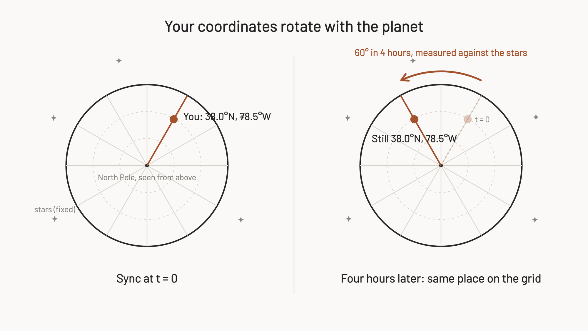
One more intuition to disarm before the math: Earth turns 60 degrees of longitude every four hours, so does the camera's synced GPS fix drift thousands of kilometers stale over an afternoon? No. Latitude and longitude are coordinates on the rotating planet, and the rotation carries the camera and the entire grid around together: hours of rotation change your position by exactly zero (assuming of course that you actually don't change location).
That is also what makes the correction computable at all. The Earth-rate vector at a fixed spot never changes, so a location fix goes stale only when the photographer travels, never from the planet turning underneath.
How Big Is the Effect?
The magnitude of this one actually took me by surprise. Earth's sidereal rotation rate is 7.292 x 10⁻⁵ radians per second, which works out to 15.04 degrees per hour.⁴ Small, but sensors resolve small angles. The drift in pixels is the rotation rate, times the exposure time, times the focal length, divided by the pixel pitch.
For the X2D II (3.76 micron pixel pitch), in the worst-case geometry (more on that below), that results in:
| Exposure | 25mm | 38mm | 55mm | 90mm |
|---|---|---|---|---|
| 1s | 0.5 px | 0.7 px | 1.1 px | 1.7 px |
| 4s | 1.9 px | 2.9 px | 4.3 px | 7.0 px |
| 8s | 3.9 px | 5.9 px | 8.5 px | 14.0 px |
| 32s | 15.5 px | 23.6 px | 34.1 px | 55.9 px |
The one-pixel line gets crossed between 0.57 seconds (90mm) and 2.06 seconds (25mm). The net takeaway here is that, uncompensated, shorter focal lengths should have less earth-rotation-induced blur than longer focal lengths.
Every doubling of exposure doubles the drift. Try it yourself:
Drift calculator · X2D II, 3.76µm pixels
Now put that against what a 10-stop rating promises. Hasselblad's own FAQ works the example: a safe handheld shutter of 1/500s becomes about 2 seconds with 10 stops of compensation.² Apply the same 1024x shift to the 1/focal-length rule and a 10-stop system is implicitly claiming usable exposures of roughly 11 to 41 seconds across those focal lengths. At 32 seconds, uncompensated Earth rotation alone contributes 16 to 56 pixels of drift. The claimed exposures are an order of magnitude past the point where the planet becomes the dominant blur source. Of course this is just the math, and real-world results are unlikely to come anywhere near this level of compensation.
You can fold the same numbers into a stops ceiling, the way an analysis at The Center Column first did for a 24MP full-frame sensor, arriving at about 6.3 stops.⁵ Rerun that method with the X2D II's smaller 3.76 micron pixels and the ceiling comes out at about 5.7 stops.
Three assumptions ride along with that figure: a one-pixel blur criterion, the 1/focal-length handheld convention, and worst-case pointing geometry. Move any of them and the number shifts a stop or so in either direction. Treat it as an order-of-magnitude result, not a spec.
The direction of the pixel-density effect is worth pausing on, though: a 100MP medium format sensor hits this wall sooner than a 24MP full-frame sensor, because finer pixels resolve the same angular drift earlier.
Why Can't the Camera Just Measure It?
The obvious fix would be for the camera to sense Earth's rotation and subtract it. It cannot, and the reason is the noise floor of its own instruments.
Consumer-grade MEMS gyroscopes, the class of sensor that fits in a camera body, carry a bias instability on the order of 50 degrees per hour or more.⁶ The planet's 15-degree-per-hour signal is under a third of the sensor's own wander, on the most favorable laboratory metric. The inertial navigation field even defines its sensor grades around exactly this threshold: "tactical grade" formally means a gyro that can measure Earth rate at all, and that hardware lives in missile guidance and platform stabilization, not in consumer cameras.⁶
So the practical route is to compute the answer instead of sensing it. Earth's rotation is perfectly predictable: a fixed vector, parallel to the planet's axis, magnitude known to nine digits. If the camera knows where it is and which way it points, it can calculate exactly what portion of the gyro signal is the planet and subtract it.
This is not a new idea. Inertial navigation systems have carried Earth-rate terms in their equations since before the transistor,⁷ ⁸ and a gyrocompass finds true north by using Earth's rotation as its signal rather than treating it as noise.³ Hasselblad's contribution is packaging a century-old navigation correction into a camera body.
Have you seen the guide? I've published Essential Phocus 4.x for Mac - 85 topics across 8 sections and 250 pages covering everything from HNCS color science to HDR workflows. It's the reference manual Hasselblad hasn't updated since 3.8. It's $49, and updates are included.
Why Latitude and Compass Direction Both Matter
Here is where Hasselblad's FAQ wording gets specific: "Using location and compass information compensates for Earth's rotation effects on stabilisation."² Both inputs are load-bearing, and the interactive below shows why. Earth's spin is one fixed arrow in space: 15.04 degrees per hour around the polar axis. But the camera's gyro doesn't speak "polar axis." It speaks pitch, yaw, and roll. How that one arrow translates into those three words depends entirely on which way the camera faces. Drag the sliders and watch the same spin become three different kinds of drift.
Simulated long exposure · what Earth's spin does to the frame
Where you stand, where you point
The same spin, in gyro language (°/hr)
One arrow, three words
Earth rotates around a single axis, the line through the poles. That rotation is the same everywhere on the planet: one arrow, fixed in space, 15.04 degrees per hour. Your latitude decides how that arrow sits relative to your horizon (at the north pole it points straight up; at the equator it lies flat along the ground, pointing north).
The gyro, though, reports rotation about its own three axes: pitch (nodding up and down), yaw (shaking side to side), and roll (tilting around the lens axis). Those axes are bolted to the camera body. Turn the camera, and the axes turn with it.
Researching and writing the blog and page posts I produce takes up a lot of my time and costs me money for software subscriptions, tooling, and other incidentals related to running a business.
Please consider a paid membership to help me keep the lights on and pay the bills - it is only a fraction of the cost of an X2D II and a lens. Click on the button to go to the membership page to see the options available.
Pointing decides the split
Try the presets. Point the lens at Polaris and Earth's arrow runs straight down the lens barrel: the entire 15.04 degrees per hour lands on roll, and the sky pinwheels around the center of the frame. Point due east at the horizon from the equator and the arrow now runs across the camera from left to right: the same rate is now pure pitch, and stars climb straight up through the frame. Point somewhere in between and the spin splits into a mix of all three.
The total never changes. Only the recipe does. And the recipe is set by two things: your latitude (how the arrow sits against your horizon) and your pointing direction (how your camera's axes sit against the arrow). Standard navigation math makes the latitude half precise: the horizontal component scales with the cosine of your latitude, the vertical component with the sine, and the east component is exactly zero everywhere.⁸
Why the stabilizer cares about the recipe
The sensor corrects each axis with a different physical motion. Roll drift needs the sensor to rotate. Pitch drift needs it to slide one way; yaw drift, the other. A correction built from the wrong recipe moves the sensor in the wrong pattern, and the residual smears the exposure.
So knowing "we are drifting at some fraction of 15 degrees per hour" is not enough. The camera has to compute the expected drift per axis, and that computation needs exactly the two inputs the gyro cannot supply: where on Earth it is, and which way it points. The gyro measures the sum of true camera motion and Earth's spin; only by independently computing Earth's contribution, axis by axis, can the camera subtract it and treat what remains as real movement.
The merry-go-round version
Sit on a slow merry-go-round with a camera. Point the lens straight up along the center pole: the world spins around the middle of your frame, a pure rotation. Now point the lens outward at the horizon: the scenery streams sideways past you, a pure pan. The merry-go-round didn't change. You just pointed the camera differently, and the identical rotation showed up in the image as two completely different motions. Earth is the merry-go-round; it just turns once a day instead of once a minute.
Where the compass has to live
A consequence worth spelling out: the heading input cannot come from the phone. The pointing direction changes every time you recompose, tilt up, or turn to face a different subject, and the compensation needs the current direction, not the one from the last app connection. Your iPhone, meanwhile, is in your pocket facing some unrelated direction, and it is not even connected mid-shot. So while latitude comes from Phocus Mobile 2, the compass bearing has to be measured continuously in the camera body itself, which points at an onboard magnetometer.
Hasselblad's spec sheet never lists one, so read this as inference, but the manual's own caution supports it: the feature "may fail" in "high latitude areas or regions with strong magnetic fields."¹⁰ That failure mode fits a magnetometer exactly: near the magnetic poles the horizontal field component that gives a compass its bearing gets weak, and strong local fields corrupt it anywhere. Lose the heading and the vector math above has a missing input.
Two Ways Out, and Who Chose Which
The limit is real, and the industry record shows two independent escapes from it, which is itself decent evidence that the physics is genuine rather than one company's marketing story.
Olympus hit the wall first and went through it with hardware. After the 2016 "rotation of the earth" statement, the 2019 E-M1X shipped with a claimed 7.5 stops, and when Imaging Resource asked directly whether GPS and compass data were involved, Olympus engineers said no: they had co-developed a quieter gyro with Epson and roughly doubled the sensor performance instead.⁹ Better instruments, same blind spot, pushed further out.
Hasselblad went the other way: leave the gyro alone and compute the correction from synced location plus compass information (the FAQ's word; where the compass reading physically lives, Hasselblad does not say beyond the inference above). Neither approach is wrong. The hardware route needs no user cooperation but fights the noise floor; the computed route is exact in principle but depends on fresh location data, which is why the X2D II suggests you connect Phocus Mobile 2 before shooting, and why that data expires.
Worth stating the limits of the claim plainly. A 10-stop CIPA rating is measured on a shake table under standardized conditions, and nothing public shows whether that test would even expose an Earth-rotation deficit; a rating this high is hard to explain without some active handling of the Earth-rate term, but the test methodology leaves room, and Hasselblad has never published how many stops the compensation itself contributes.
Nobody outside Hasselblad seems to have measured the feature's real-world benefit. What the math above establishes is narrower and more durable: at the exposure lengths a 10-stop rating implies, Earth's rotation is a first-order problem that every gyro-stabilized camera either engineers around or eats. For a deeper look at how the X2D II's stabilization generation compares to its predecessor's, see my X2D II vs X2D 100C comparison.
References
- PetaPixel: Olympus Says Earth's Rotation Limits Image Stabilization to 6.5 Stops Max (2016)
- Hasselblad X2D II 100C FAQ
- Wikipedia: Gyrocompass
- Wikipedia: Earth's rotation (IERS angular velocity)
- The Center Column: Earth's Rotation Limits IBIS Performance to 6.3 Stops
- Larocca et al., Sensors 2021: seismological measurements with consumer-grade MEMS sensors (bias instability figures and the tactical-grade definition)
- Wikipedia: Schuler tuning (Earth-referenced corrections in inertial navigation)
- Braasch, Inertial Navigation Systems chapter excerpt (Wiley): Earth-rate decomposition in the navigation frame
- Imaging Resource: Olympus E-M1X interview on stabilization improvements
- Hasselblad X2D II 100C User Manual v1.0, section 2.8, Image Stabilisation